Compare one night’s sleeping-elevation change against the published figure. No itinerary, no comparison, no report — just the single number.
Route templates
8
Rules applied
8
Guidance sources
2
Itineraries compared
2
01 · The problem
The itinerary tells you where you sleep. It doesn't tell you how fast you climbed to get there.
An itinerary is a list of places
Day four, Horombo Hut. It tells you where the group will be, not how much higher you sleep than the night before.
The guidance is written in a different unit
Published gradual-ascent guidance is written in change of sleeping elevation per day. Your itinerary is written in place names.
The person answering is the person selling
The operator sets the schedule. An independent read of the same numbers is a different thing from asking them whether their schedule is fine.
Two quotes are hard to tell apart
Six days or seven, one price or another. Without the profile side by side, the difference is a feeling rather than a number.
02 · The promise
Five steps, ending in questions you can actually send
Enter, audit, compare, question, print. Every night gets measured against the published guidance, and the run ends in a printable report with a specific question for each one that’s flagged.
Enter, then Audit, then Compare, then Question, then Print
01Enter
02Audit
03Compare
04Question
05Print
01Enter
02Audit
03Compare
04Question
05Print
What the sleeping-elevation pattern in your itinerary actually looks like, night by night, rather than as a list of place names
Which nights sit outside the per-day figure published guidance references, and by how many metres
How two itineraries you've been quoted differ on measurable things: nights above 3,000 m, nights without ascent, and how much elevation is gained before one
Where published elevations for the same camp disagree between sources, and which figure the audit used
What to ask the operator, phrased as a question they can answer rather than a complaint
03 · How it works
7 chapters, run in order
Each chapter builds on the last one. You're never asked to guess at something an earlier chapter already covered.
01
Enter your itinerary
Pick one of eight route templates or type your own. Every prefilled figure stays visibly ours until you confirm or replace it.
02
Night-by-night audit
Each night's sleeping-elevation change, compared against the figures published by CDC and the Wilderness Medical Society.
03
The ascent profile
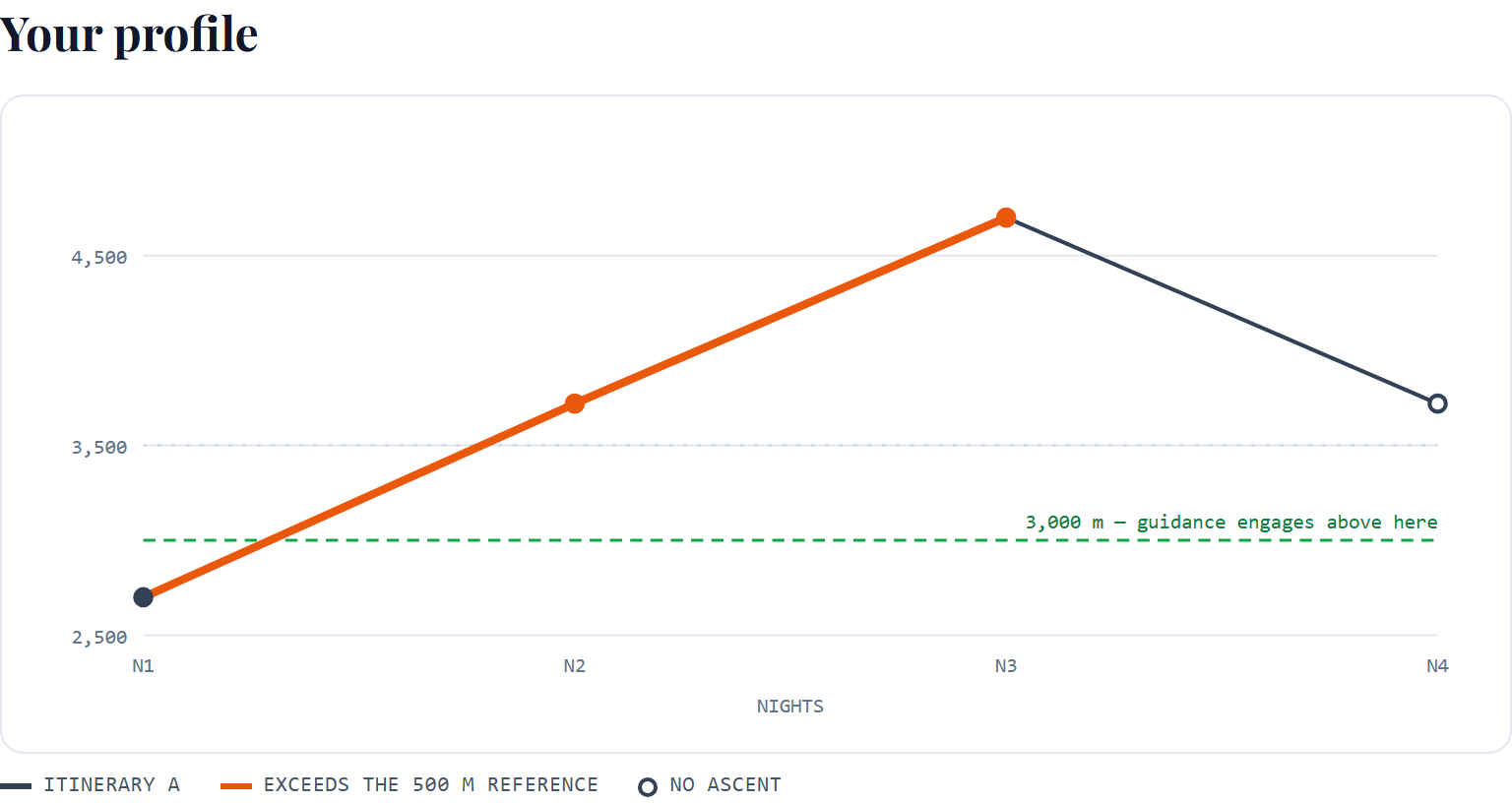
Your whole trek as one chart, with the 3,000 m line drawn and the segments that exceed the reference marked.
04
A and B side by side
Two quoted itineraries on the same axes, compared on objective metrics only.
05
Questions for your operator
Every flagged segment becomes a specific, neutral question, with your own numbers in it.
06
The printed report
Summary, chart, night table, flagged segments, questions, evidence and limitations, as one document you can keep.
07
The field card
A6, one side: your nights, the flagged ones, and blank fields for your operator, insurance and evacuation contacts.
04 · What you get
Everything included
A browser tool with a printable report and field card
1
Itinerary audit
Night-by-night sleeping-elevation analysis, with each night compared against the published per-day figure and the amount of any difference stated.
1
Ascent profile chart
Your whole trek on one chart, with the 3,000 m line drawn, nights of no ascent marked, and the segments that exceed the reference picked out.
2
Side-by-side comparison
Two quoted itineraries on the same axes and the same metrics: nights, peak sleeping elevation, nights above 3,000 m, nights without ascent, and exceedance counts.
—
Operator questions
Every flagged segment becomes a specific, neutral question with your own figures in it, plus two that always apply: turnaround authority, and oxygen, oximetry and evacuation.
8
Route templates
Marangu 5 and 6 day, Machame 6 and 7 day, Lemosho 7 and 8 day, Everest Base Camp 12 and 14 day. Each transcribed by hand from a named source of record.
1
Printable report
Summary, chart, night table with provenance, flagged segments, questions with space for answers, the quoted evidence, and the limitations in full.
1
Field card
A6, one side: your nights, the flagged ones, and blank fields for operator, insurance, clinic and evacuation contacts.
05 · Inside
See the actual pages
Six pages from the plan, shown in full. Open any one to see it at full size.
Your whole trek as one profile, with the 3,000 m line drawn and the exceeding segments marked
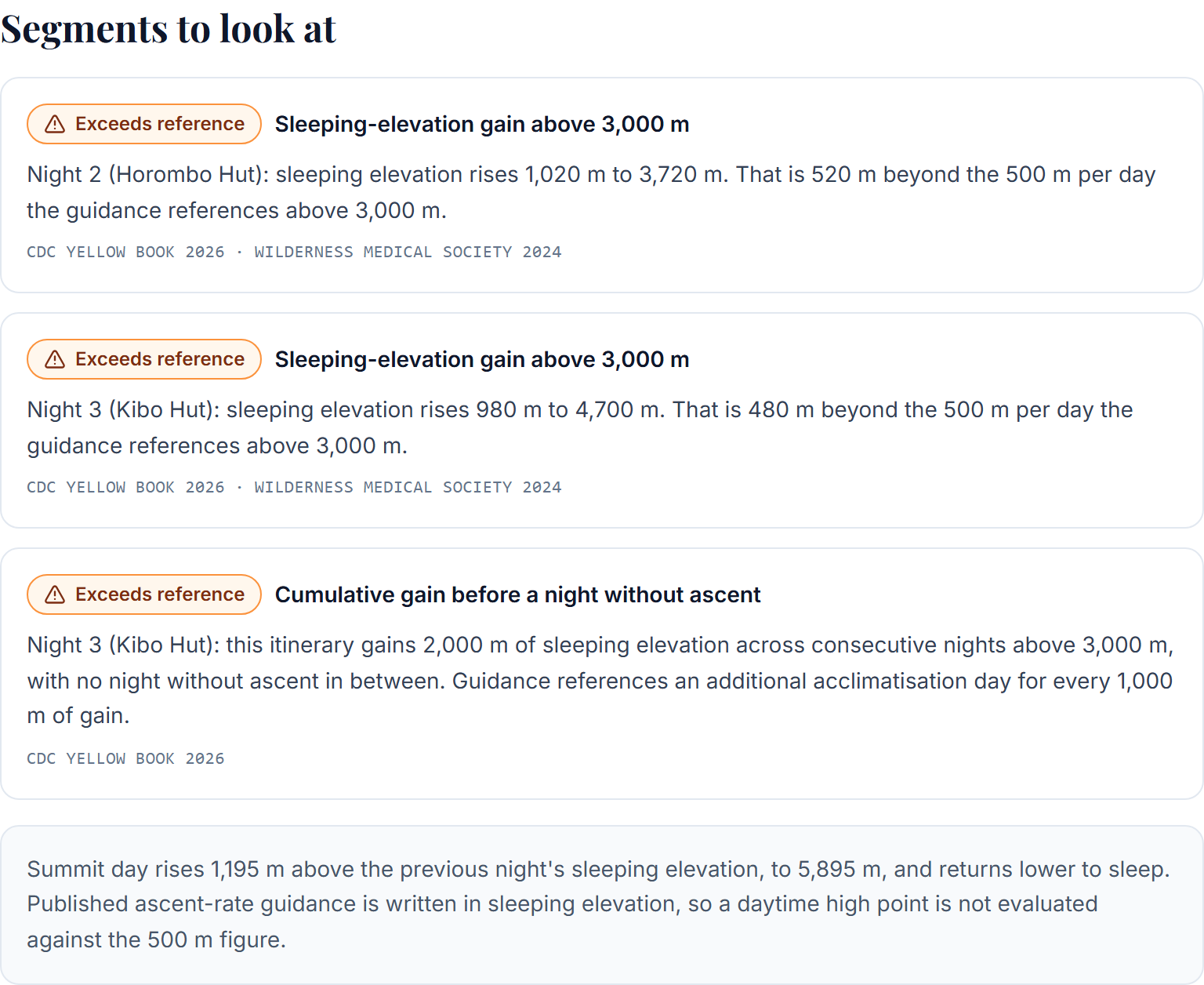
Each flagged segment, with the amount it exceeds by and the guidance it is compared against
Night by night, including a column for where each elevation came from
Two quotes on the same metrics, so the difference is a number rather than a feeling
Questions with your own numbers in them, ready to send
The field card: your nights, and the contacts you fill in before you go
06 · Evidence
Evidence, and where it stops
Two sources sit behind every comparison this tool makes.
The CDC Yellow Book 2026 publishes the per-day figure and the first-night guidance for travellers arriving from low elevation. The Wilderness Medical Society 2024 update publishes the gradual-ascent figure, the rest-day spacing, and the ascent categories the audit maps an itinerary's structure onto. Both are quoted in the report with the sentence the figure comes from, so you can read the original wording rather than our paraphrase of it.
Two things follow from taking those sources seriously.
The first is the 500 m boundary. CDC writes "no more than 500 m"; the WMS writes "under 500 m per day". Those aren't the same sentence, and a night of exactly 500 m falls in the gap between them. The audit marks that night for review and shows both quotes, rather than resolving a disagreement between two guidelines on your behalf.
The second is that the WMS categories depend on personal history — whether you've had altitude illness before — as well as on the shape of the itinerary. This tool never asks about your history, so it maps only the structural half and says so every time it shows you a category. That's a real limit, and it belongs with a travel-medicine clinician rather than with a web page.
Named in the system
High-Altitude Travel & Altitude Illness, CDC Yellow BookCenters for Disease Control and Prevention · CDC Yellow Book, 2026 edition
Wilderness Medical Society Clinical Practice Guidelines for the Prevention, Diagnosis, and Treatment of Acute Altitude IllnessLuks AM, Beidleman BA, Freer L, et al. · Wilderness & Environmental Medicine, 2024 update
The 2018 Lake Louise Acute Mountain Sickness ScoreRoach RC, Hackett PH, Oelz O, et al. · High Altitude Medicine & Biology, 2018
The thresholds are quoted, not invented
Every figure the audit compares against is printed with the sentence it came from and the source that published it. Nothing is a RoamWell rule.
Where sources disagree, you see both
Published camp elevations differ. One source of record is named per route, material alternates are kept, and the difference is shown on the night it affects.
Our numbers stay marked as ours
A prefilled elevation is labelled our figure until you confirm it against your own itinerary or type over it. The label follows through to the printed report.
The same input always gives the same output
The audit is arithmetic, not a model. Run it twice and the numbers, the flags and the questions are identical.
It stops where the evidence stops
No personal risk figure, no symptom score, no medication, no summit probability. It reads a schedule and tells you what it says.
Your itinerary stays in your browser
The audit runs on your device. Nothing you enter is uploaded, stored on a server, or put in the address bar.
What an itinerary shows you, and what it doesn't
A trek itinerary is written as a sequence of places. Day four, Horombo Hut. Day five, Kibo Hut. It reads as a list of destinations, because that's what it is: a plan for where the group will be.
What it doesn't do is present the one variable the published guidance on gradual ascent is actually written in — how much higher you sleep each night than you slept the night before.
Those numbers are usually in the document. They're just not arranged in a way that makes the pattern visible. On a five-day Marangu itinerary the nights are 2,700 m, 3,720 m and 4,700 m. Written as three lines in a table, that's three place names. Written as changes, it's +1,020 m and then +980 m, and the guidance the CDC publishes references moving sleeping altitude by no more than 500 m per day once above 3,000 m.
The audit does that arithmetic and shows you the result. It passes no judgement on the itinerary — it can't, and neither can anyone selling you one. It tells you what the schedule does, what the published figures say, and where the two differ.
Published elevations disagree, so the audit shows you where
Transcribing eight routes turned up something worth telling you about.
Reputable sources publish different elevations for the same camp. Sometimes the gap is trivial. Sometimes it isn't: on the fourteen-day Everest Base Camp itinerary, Lobuche is published at 4,940 m by one source and 4,910 m by another. Against a night at Dingboche, the first figure makes that night a 530 m change and the second makes it exactly 500 m — which is the boundary the two guidelines word differently. A thirty-metre disagreement between publishers changes how the night reads.
So each route has one named source of record, transcribed by hand rather than scraped. Where another reputable source differs materially, that figure is kept alongside it and shown on the night it affects, with what it would mean. Nothing is averaged, because an averaged elevation is a number that nobody published and no operator will recognise.
And every prefilled value stays labelled as ours — in the tool and in the printed report — until you confirm it against the itinerary your operator actually sent you. The templates are a starting point for reading your document. They aren't a substitute for it.
07 · Worked example
From start to finish, one full example
Two Marangu quotes, five days and six days, run through the audit and compared.
01Enter
The five-day template prefills four nights: Mandara Hut 2,700 m, Horombo Hut 3,720 m, Kibo Hut 4,700 m, then Horombo again after the summit. Every figure stays labelled as ours until confirmed against the operator’s own document.
02Audit
Night 2 rises 1,020 m and night 3 rises 980 m, both above 3,000 m. Each is reported with the amount it exceeds the published per-day figure by: 520 m and 480 m.
03Read
Across the run of consecutive ascent nights above 3,000 m, the itinerary gains 2,000 m before a night without ascent. There are no nights of no ascent in the five-day version.
04Compare
The six-day version adds one night at Horombo. Same peak elevation, same two exceeding nights — but one acclimatisation night, a shorter run of consecutive ascent nights, and 1,020 m rather than 2,000 m before a night without ascent.
05Ask
The audit turns each flagged night into a question with those figures in it, so the conversation with the operator starts from a number rather than a worry.
Example only. The elevations are the published template values for these two routes, and the arithmetic is the audit’s own. It’s a demonstration of what the tool reports, not a statement about either itinerary or about anyone walking it.
08 · Fit
Who it's for, and who it's not
The second list matters just as much as the first. If you're on it, this isn't the thing to buy.
Built for
Comparing two or more operators for the same trek and trying to tell the itineraries apart
Deciding whether a longer version of a route is worth the difference in price
Reading an itinerary you've already booked, before you pay the balance
Preparing questions to put to an operator, and wanting them specific rather than vague
Walking to Everest Base Camp or up Kilimanjaro, or anywhere else you sleep above 3,000 m
Not built for
Anything medical. It makes no assessment of you, scores no symptoms, interprets no oxygen readings and says nothing about medication
Emergency decisions on the mountain. Those belong to you and your guide, in person
Choosing an operator for you. It compares itineraries, never companies
Fitness, training or gear. Different job, different product
Predicting whether you'll summit. Nothing can do that, and this doesn't pretend to
09 · Anywhere
Works wherever you are
Elevation
m · ft
Runs in
Your browser
Report
Print or Save as PDF
Field card
A6, one side
Metres or feet, switchable at any point, with the same result either way
Eight route templates at launch, or type any itinerary yourself
Runs in the browser. No upload, no itinerary stored on a server
The printed report works from any browser's print dialog, including Save as PDF
Thresholds are shown in the units each source published them in
What this is, and what it is not
Educational and planning guidance only. This tool compares an itinerary against published ascent guidance. It's not medical advice, it doesn't assess you, it scores no symptoms, and it makes no prediction about what will happen on your trek. For anything about your own health, speak to a travel-medicine clinician before you go, and to your guide on the mountain.
10 · Questions
Before you decide
What does the audit actually analyse?
Sleeping elevation, and how it changes from night to night. It computes each night's change, how long you go without a night of no ascent, and how much elevation is gained across such a run, then compares those against figures published by the CDC Yellow Book and the Wilderness Medical Society. It does not analyse distance, terrain, walking hours, fitness or load.
Which treks are supported?
Eight route templates ship at launch: Kilimanjaro via Marangu (5 and 6 day), Machame (6 and 7 day) and Lemosho (7 and 8 day), plus Everest Base Camp (12 and 14 day). More can be added as data files without changing how the audit works.
Can I enter an itinerary that isn't one of the templates?
Yes. Choose "Enter my own itinerary" and type the nights yourself. The templates are a convenience for routes we've transcribed, not a limit on what the tool can read.
Can I compare two itineraries?
Yes. After the first audit you can start a second itinerary, either from another template or as a copy of the first, and the two are compared on objective metrics: nights, peak sleeping elevation, nights above 3,000 m, nights without ascent, how many nights exceed the reference and by how much in total, and the longest run of consecutive ascent nights.
What happens when published sources disagree about a camp's elevation?
They often do, sometimes by enough to change how a night reads. Each route has one named source of record, and where another reputable source differs materially the alternate figure is stored and shown on the night it affects, with what it would mean. Values are never averaged, because an averaged elevation is a number nobody published.
What is in the report?
A cover with the date, the guidance editions used and the route sources; a summary; the profile chart; the night-by-night table including where each value came from; the flagged segments; the operator questions with space to write the answers; the evidence with the quoted sentences; and the limitations in full. The A/B comparison is included if you made one, and the field card if you asked for it.
Is this medical advice?
No. It compares an itinerary against published guidance and stops there. It makes no medical assessment, scores no symptoms, interprets no oxygen readings, says nothing about medication, and gives no personal risk figure. For anything about your own health, speak to a travel-medicine clinician before you go, and to your guide on the mountain.
Does the tool store my itinerary?
No. The audit runs in your browser, nothing you enter is sent to a server, and nothing is written into the address bar. The report is held in the tab you generated it in, which is why refreshing that page clears it.
Can I work in feet?
Yes, and you can switch at any point. Everything is stored and compared in metres internally, so the verdicts are identical either way. Published thresholds are shown in the units the source printed them in, rather than converted.
Can I use it before I book?
That's the moment it's built for. It's most useful while you still have two quotes open and haven't paid the balance, because the questions it produces are ones you can put to an operator before you commit.
What is the difference between the free checker and the full audit?
The free checker compares a single night: two sleeping elevations in, one comparison out. The audit reads a whole itinerary, so it can see rest-night spacing and the shape of the trek, compare two itineraries, generate the operator questions, and produce the report and field card.
Why is one night marked for review rather than passing or failing?
A change of exactly 500 m sits on a boundary the two cited sources word differently: one says no more than 500 m, the other says under 500 m. Rather than pick a winner between two guidelines, the audit marks that night for review and shows you both sentences.
Can I get a refund?
Once access to the tool has started, we generally don't offer refunds just because you changed your mind or didn't get around to using it, which is why this page goes into so much detail about what the tool does and what it deliberately doesn't do. That is subject to the law that applies to you, and it is not a promise that every request will be refused. If a charge was made twice, the tool won't load or you can't get into it, or it is materially different from its description, contact us and we'll try to put it right first, and give any remedy the law requires if we can't. We also look into unauthorised payments and payment disputes. The full policy is on our refund page.
What happens after I buy?
Checkout opens in a new tab and payment is handled by Razorpay, so RoamWell never sees your card details. Once Razorpay reports the payment, our server verifies it against the order before anything is granted. You are then taken to the thank-you page, where you can start your Ascent Profile Audit. Where checkout asks you to sign in with your email, the purchase is linked to that account and you can open the audit whenever you sign in to it, on any browser or device. Otherwise, access is valid for 30 days, in the same browser you paid from, so keep that browser. Purchases made before sign-in checkout opened keep that 30-day, same-browser access. If browser access is lost, contact us and we will review it, though we cannot promise access can be restored in every case. The audit runs as a web tool on this website, so there is no file to download. Our delivery and refund terms are on the refund policy page.
The RoamWell · Digital product
The Ascent Profile Audit
Read the sleeping-elevation pattern in the itinerary you were quoted